Geospatial mapping and analysis for mines
Leverage geospatial data to better understand mining operations.

Using geospatial tools for volumetric measuring on mining sites
Learn how to measure soil amounts removed from quarries or mines and estimate materials stored in piles.
Hexagon provides mining teams and stakeholders with mapping, remote sensing and 3D visualisation tools to enhance site analysis and operations.
Overview
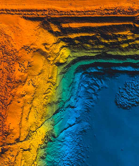
Accurate knowledge of locations is vital to mining operations. Location-based data can provide mining companies and stakeholders with more in-depth understanding of mine sites.
They key is to turn this data into usable information and insights. Hexagon’s geospatial mapping and analysis capabilities help organisations see sites like never before through 3D visualisation and advanced analysis to improve safety, sustainability and productivity.
By leveraging satellite imagery, elevation data, LiDAR and other data sources, mining companies can conduct feasibility studies, map infrastructure, calculate resources, monitor site progress, assess risk, monitor reclamation and perform other critical tasks. They can also combine spatial and business data in easy-to-use dashboards and portals to deliver the latest maps and information to site operators, business users, regulators and others to empower operations, business analysis, compliance and more.

Explore products
$ProductName
$SustainabilityImpactLabel
$SustainabilityCTABandHeadingLabel
We’re climbing the automation curve
Our transition to Intelligent automation is accelerating. Ultimately, our innovations will give rise to new technologies and applications - many of which we’ve yet to imagine. Today, every Hexagon solution is mapped and tagged according to its level of automation, so customers can clearly track our progress towards the freedom of autonomy.
-
Level 0/None:
Human performs all tasks, no data being used
-
Level 1/Human-assisted:
Human is in charge of performing tasks but certain functions are automated to simplify control
-
Level 2/Partial:
Some tasks are automated so that operation can be autonomous for short periods (or within specific circumstances)
-
Level 3/Conditional:
Autonomous operation is possible within certain bounds, but human intervention may be necessary at short notice
-
Level 4/High:
Designed to complete required tasks autonomously, but may require human intervention if circumstances change beyond specific bounds
-
Level 5/Full:
Control tasks automated under all conditions, but human may request to take over; can complete all expected tasks without human intervention
Our sustainability influence
Our solutions create meaningful improvements in quality, efficiency, productivity, and safety – the antidotes to the status quo of waste, pollution, diminishing margins, and increased risk. Explore the highlighted products helping industry address environmental challenges in land, air and water.
Land
Products that make an environmental impact in forest monitoring, material reusability, farming or water usage.
Air
Products that make an environmental impact in renewable energy, noise pollution elimination and e-mobility.
Water
Products that make an environmental impact in saving our oceans, reducing pollution and increasing access to clean water.