Unified GIS solution reduces pipeline maintenance costs
Hexagon geospatial technologies provide deeper insights into the infrastructure's behavior over time

The challenge
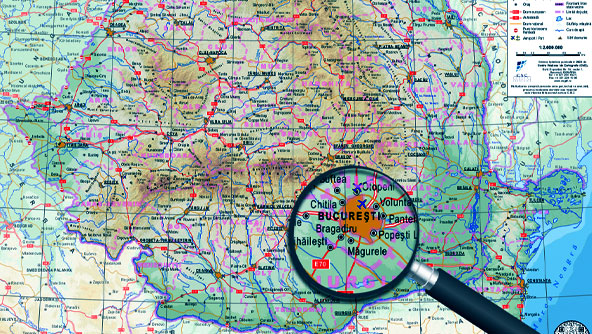
CONPET S.A. in Romania operates an extensive national network – the National Pipeline Transport System – that includes 3,800 kilometers (approximately 2,361 miles) of pipeline and is instrumental in fueling refineries with domestic and imported crude oil products. The system integrates a vast infrastructure spanning 24 counties that, in addition to pipeline, includes numerous pumping stations, loading ramps and storage facilities.
Before, CONPET relied on disparate applications and needed a unified GIS solution to integrate and manage its geospatial data, enable consistency and reliability of that data and comply with international pipeline management standards. There was also a critical need for a system that could offer real-time planning and dispatching of field operations, as well as monitoring the pipeline’s integrity.
The solution
CONPET turned to Hexagon partner Intergraph Computer Services (ICS) Romania, which built a GIS solution using Hexagon’s GeoMedia Professional, GeoMedia WebMap and M.App Enterprise technologies. The solution is a unified system for pipeline data collection, advanced geospatial analysis, dynamic map creation and the distribution of geospatial data via web services. It also enables online information sharing and ensures regulatory compliance. M.App Enterprise allows CONPET to model business workflows and integrate its sophisticated management dashboards.
By providing deeper insights into the infrastructure’s behavior over time, the system is reducing operational and maintenance costs. Continuous monitoring of risk zones along the pipeline network allows CONPET to address potential problems before they escalate into actual incidents. Identifying areas with high incident impact, the new system facilitates targeted interventions, which are crucial in minimizing the effects of any disruptions and ensuring rapid response. Since the Hexagon system went live, CONPET has recorded a significant decrease in maintenance costs.
Learn more
Also explore
M.App Enterprise