A hierarchical approach to reality capture

Established in 2016 in Ottawa, Canada, the If Then Architecture Inc. founders want to help their customers design, construct, operate and maintain their buildings. All three founding partners are research alumni of the Carleton Immersive Media Studio (CIMS) at Carleton University, which gives them a solid background in the application of digital technologies in architecture. This knowledge, combined with 3D laser scanners from Leica Geosystems and Building Information Modelling (BIM), allows them to generate accurate and reliable deliverables.
The multi-tool approach
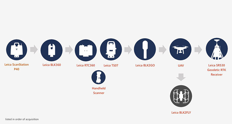
The initial scanner acquisition included the Leica ScanStation P40, followed shortly by the addition of the Leica BLK360 G1, enhancing their ability to capture detailed scans of smaller spaces. Not long after that, they bought a Leica RTC360 and the Leica TS07 for higher quality and speed of scans. The speed and quality of the RTC360 is often combined with the precision and accuracy of the TS07 to create high-quality deliverables. Later, the Leica BLK2GO was added, which allowed them to scan more and larger buildings in less time.
Every time they embark on a new project, their team assesses the site and project specifications to decide on the appropriate scanners to use. The selection is determined by the following criteria:
- Project specifications and/or requirements
- Site conditions
- Building conditions
- Field conditions and constraints
- Weather and climatic conditions
- Size of field crew
After defining the priorities of the criteria together with the customer, the right scanners are selected for the project. To avoid interruptions during the scanning process, they always choose multiple scanners for the best possible quality. With the procured scanners, the team has a broad selection of tools. After the scanners have been chosen, they can proceed to the construction site and start with their hierarchical scanning process.
“Every building is different, and when you stand in these spaces, you realise just how different buildings can be when you break them down for data capture. For this reason, we rely on a multitude of tools to handle the various conditions and dynamics that we encounter in the field,” said Darcy Charlton, Principal Architect of If Then Architecture Inc.
Hierarchy is key
Whenever If Then Architecture Inc. starts a new project, it consistently follows the same approach to the scanning process. At the construction site, they first set up a basic exterior and then interior control network either with an external surveyor or with their own total station using the ScanStation P40.
These control points are ideally set at key intersections in the circulation spaces of the building so that every new set-up is just two or three scans away from an easily accessible control point. Once the control points are set, they create an exterior envelope. Distant setups with the ScanStation P40 and its traverse function establish levelness, and the RTC360 is used to create infill scans of smaller spaces.
“Establishing a 3D control network using our Leica TS07 Total Station allows us to accurately register our RTC360 data and to produce a reliable and levelled dataset,” mentioned Charlton.
The next step is to create a vertical circulation using either the BLK2GO for efficiency or the ScanStation P40 or RTC360 for accuracy. After completing the vertical circulation, the field crew tackles the primary circulation for the corridors with the ScanStation P40 or RTC360. The procedure for this step is the same as before, with the ScanStation P40 being used to set up control points and levelness before the RTC360 is set up to fill in the gaps.
Lastly, they can begin the secondary circulation for the rooms to finish the project. For this task, they always use the RTC360 for faster acquisition speeds that can easily capture up to 100 scans per day. Alternatively, the BLK2GO is used when a lower resolution is sufficient for the client.
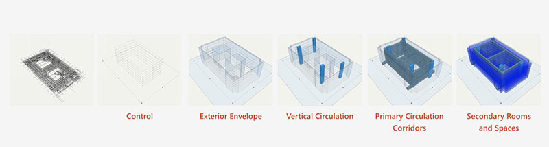
With these five steps, the If Then Architecture Inc. team can easily take on any project and deliver high-quality deliverables for every step individually:
- Set up control network
- Exterior envelope
- Vertical circulation
- Primary circulation - corridors
- Secondary circulation - rooms and spaces
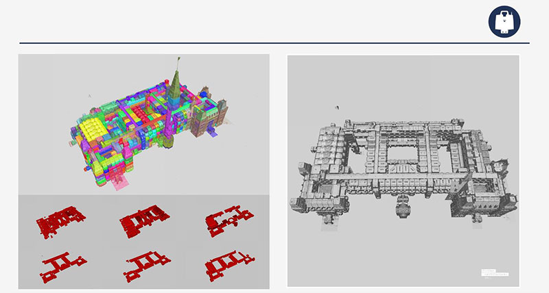
After completing the scans, they process the captured data using Leica Cyclone and Autodesk ReCap to generate project deliverables, which are organised according to the areas scanned. The client then receives individual scan files for each of the different rooms or building areas, and a combined file is also provided linking the individual scan files into a single coordinate system. Based on the data from these deliverables, the client can precisely plan the projects they want to realise for that building. Adhering to this scanning process, If Then Architecture Inc. can create more accurate deliverables of the buildings significantly faster compared to traditional methods, allowing them to take on more projects.
The process during projects
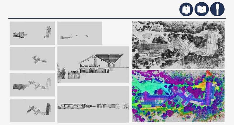
The McMichael art gallery in Toronto, Canada, desired to have their gallery documented, and this task presented a greater challenge than initially thought. The location posed several obstacles due to its forest surroundings, limited exterior space, and restricted lines of sight. Additionally, since no doors or windows could be opened during the scans, they were only able to establish a single registration tie point at the visitor entrance.
“From there, we really had to rely on the accuracy of the RTC360 and its VIS technology, along with the BLK2GO, to generate an accurate registration of all interior data. While reviewing the registration results, we observed that all interior door and window frames were neatly and accurately aligned – both horizontally and vertically - with the exterior data set; even at the far end of the art gallery, calling attention to the remarkable angular accuracy of the RTC360 and BLK2GO” said Charlton.
An additional example of the advantages of laser scanners became apparent to them in a project for the Bank of Montreal Museum. In this project, the ScanStation P40 and RTC360 were complemented by a UAV to generate photogrammetric images of the inaccessible roof of the building.
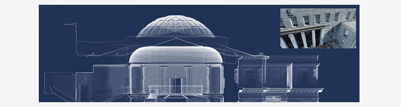
As they combined all the scans and images to create the deliverables, they noticed that the photogrammetric images did not result in an accurate model. In the side view image of the building, it became visible to them that the accuracy of the roof was not comparable with the rest of the building that was captured with laser scanners. This prompted them to evaluate acquiring the Leica BLK2FLY for more accurate scans of inaccessible areas.
Benefits of the Hierarchical Approach
Looking at the Hierarchical approach to projects such as If Then Architecture Inc. shows that there are many benefits. A concise summary will provide a clearer understanding of the positive influence this technology can bring to any company:
- Increased accuracy
- Increased efficiency
- Increased quality of deliverables
- Redundancies using multiple scanners
- Freed-up team members are available for other projects
”After adopting Leica Geosystems laser scanners, we have noticed a significant improvement in both the quality and accuracy of our project deliverables. Not only that, but it now takes us less time to complete field and office tasks, allowing us to take on more projects and to create better value for our clients. This, along with many other benefits, have propelled us to gradually acquire more Leica equipment, software, and accessories in order to develop and refine our building documentation processes and workflows further,” Charlton said.
Currently equipped with multiple scanners, they have robust strategies in place to ensure seamless project execution. Adopting laser scanners and software solutions to process the scans had a significant impact on their business, enabling them to expand their business and increase their profits.