Scanning a sixty-year-old steel bridge: metrology in extreme conditions
Retrofitting Success: Advanced Scanning for Structural Integrity

Collaborative Efforts for a Complex Project
When a local German government needed to retrofit a 60-year-old steel bridge used for freight trains, the project’s construction company turned to metrology expert Hilmar Schroeder of HS 3D-SOLUTIONS GmbH for assistance. Schroeder, known for his innovative approach to complex projects, eagerly accepted the challenge. To ensure the project’s success, he reached out to his long-time collaborator, Christian Sommer of Sommer3D Engineering GmbH, to join forces on this demanding assignment.
Sommer and Schroeder have a history of collaboration despite working for different companies. So when Schroeder received the call from the construction company requesting his metrology expertise, he knew he could count on Sommer to help tackle the project. “Hilmar always has these kinds of projects that are out of the box. He says to the customer, ‘We can do the job,’ and after that, he calls me, and we sit down and figure out how to make it happen. And so far, we’ve always succeeded,” Sommer explained with a laugh.

Challenges: Thin Steel, Harsh Environment, and No Existing Drawings
At the center of this unusual metrology project was a freight train bridge made of 5mm thick steel that had been used for more than 60 years. Unfortunately, local engineering staff had no blueprints or drawings to help inform retrofit decisions.”The only way to get new drawings of the bridge is to scan it with the highest accuracy possible,” Sommer said. The steel parts are really thin, with a wall thickness of five millimeters. We knew room scanners wouldn’t work and that we’d need something that could go beyond their accuracy limits.” Battling the elements
Beyond the lack of blueprints, Sommer and Schroeder faced numerous logistical challenges on the project. Scanning such a thin material in an outdoor environment would prove to be difficult. The metrology project occurred in November, which meant Sommer and Schroeder had to contend with cold, wet weather while capturing the bridge’s intricate geometry — both underneath and on top of the surface.
Due to the bridge’s remote location, the team had to erect a tent to protect their equipment from the elements and use a generator to power their tools. They also needed to calculate the bridge’s weight-bearing allowance to ensure the safety of their equipment and personnel during the scanning process.
Navigating logistical hurdles
The project also required working safely around different train schedules. “Along with everything else, we had to work around trains traveling across the bridge. The frequency varied — sometimes they’d pass through every 60 minutes and other times every 10 minutes. The train operator’s security team took care of us, which often meant we had to stop scanning and wait until they gave the okay that no trains would be passing and it was safe to start again,” Sommer said.
Solution: Advanced Hexagon Hardware and Software
To tackle this complex project, Sommer and Schroeder relied on a combination of advanced Hexagon hardware and software, including:
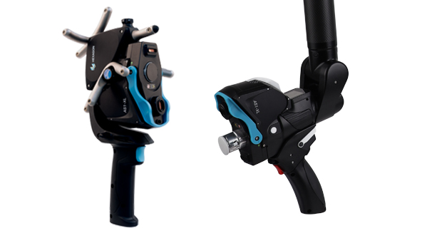
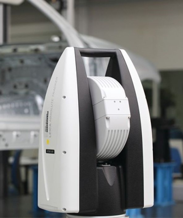
- Absolute Tracker AT960 laser tracker for high accuracy data capture
- Absolute Tracker ATS600 direct scanning laser tracker for inspecting large parts
- Absolute Scanner AS1-XL for scanning hard-to-reach areas
- 20 scanning stations bundled together for comprehensive coverage
- 15 reference spheres mounted on the bridge for precise alignment
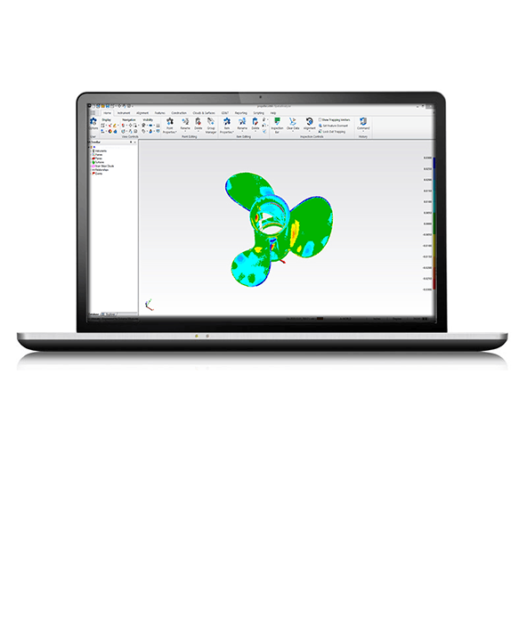
- SpatialAnalyzer® software for data processing and analysis
- Inspire software for intuitive scanner control
“We focused on two different sets of hardware — the ATS600 and the AS1-XL. The ATS600 is designed to scan large areas — it can do line scanning by defining a perimeter and scanning everything inside. It can also draw a line and scan across that line, something that worked really well for these thin steel parts. Using this gave us the highest accuracy possible — we scanned below one millimeter in terms of system noise and accuracy. For 90 percent of the parts, we could use the ATS600 to get a true digital twin in terms of the point cloud,” Sommer shared.
He continued, “We opted for the AS1-XL to scan the joints and connections between the different steel parts — especially from the top side — because it let us go inside the parts with it and capture those hard-to-reach areas.”


Unifying scanning locations with USMN
One critical aspect of the team’s solution was using SpatialAnalyzer’s USMN (Unified Spatial Metrology Network) feature, which enabled them to set up 20 scanning locations on a single network. This unique capability, only available in Inspire and SpatialAnalyzer, facilitated the seamless integration of data gathered from multiple stations.
 “One major advantage of SpatialAnalyzer is once you have measured all the different locations, you do one single network alignment, which automatically aligns all the instruments to each other. The network alignment uses weightings based on instrument accuracy, so you get an optimized result. Measurements with less accuracy have less influence, while measurements with higher accuracy have a higher impact. This allowed us to get the most out of our data in terms of accuracy for the overall point cloud,” he said.
The team found Hexagon’s AS1-XL scanner and Inspire software invaluable in capturing hard-to-reach areas of the bridge. Inspire’s intuitive controls enabled the team to control the scanner directly from the handheld device, streamlining their scanning process. The team saved hours because Inspire eliminates the need for cumbersome mouse navigation through nested menus.
According to Sommer, “Inspire does a great job of displaying the scan points in real-time with the AS1-XL so that we could handle the amount of data coming in. It provided feedback indicating that we’d scanned enough or needed to scan more, allowing us to evaluate it in realtime.”
Knowing that accuracy was paramount, the team took precautions to ensure their measurements were correct. “Whenever a train was passing by, we stopped the scan — and after it passed, within SpatialAnalyzer, all we had to do was click a single button, and it would re-measure all visible points. We could see if the train passing influenced our scan data; if it showed it did influence it, we reset things, but if it had no influence, we continued to scan. This enabled us to effectively maintain our scanning accuracy, guaranteeing that the measurements we were gathering were as accurate as possible,” he said.
One critical aspect of the team’s solution was using SpatialAnalyzer’s USMN (Unified Spatial Metrology Network) feature, which enabled them to set up 20 scanning locations on a single network. This unique capability, only available in Inspire and SpatialAnalyzer, facilitated the seamless integration of data gathered from multiple stations.
“One major advantage of SpatialAnalyzer is once you have measured all the different locations, you do one single network alignment, which automatically aligns all the instruments to each other. The network alignment uses weightings based on instrument accuracy, so you get an optimized result. Measurements with less accuracy have less influence, while measurements with higher accuracy have a higher impact. This allowed us to get the most out of our data in terms of accuracy for the overall point cloud,” he said.The team found Hexagon’s AS1-XL scanner and Inspire software invaluable in capturing hard-to-reach areas of the bridge. Inspire’s intuitive controls enabled the team to control the scanner directly from the handheld device, streamlining their scanning process. The team saved hours because Inspire eliminates the need for cumbersome mouse navigation through nested menus.
According to Sommer, “Inspire does a great job of displaying the scan points in real-time with the AS1-XL so that we could handle the amount of data coming in. It provided feedback indicating that we’d scanned enough or needed to scan more, allowing us to evaluate it in realtime.”
Knowing that accuracy was paramount, the team took precautions to ensure their measurements were correct. “Whenever a train was passing by, we stopped the scan — and after it passed, within SpatialAnalyzer, all we had to do was click a single button, and it would re-measure all visible points. We could see if the train passing influenced our scan data; if it showed it did influence it, we reset things, but if it had no influence, we continued to scan. This enabled us to effectively maintain our scanning accuracy, guaranteeing that the measurements we were gathering were as accurate as possible,” he said.
"The only way to get new drawings of the bridge is to scan it in with the highest accuracy possible."
Christian Sommer
Sommer3D Engineering GmbH
Results: Precision Digitization in Just Three Days
Despite the project’s harsh environmental conditions and complexity, Sommer and Schroeder completed the scanning process in a mere three days. By leveraging the power of Hexagon’s hardware and software, they successfully digitized the entire bridge, providing the local government with the precise data needed to create accurate drawings and plan the retrofit.The seamless integration of Hexagon’s AT960 + AS1-XL, ATS600, SpatialAnalyzer, and Inspire software enabled the team to capture and process data accurately and efficiently. SpatialAnalyzer’s USMN played a crucial role in aligning the data from multiple stations, ensuring a comprehensive and accurate digital representation of the bridge.
From point cloud to actionable insights
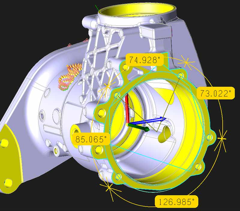
Using the point cloud data generated from the scanning process, the team created the 2D drawings essential for the retrofit planning process.”The network align functionality helped us to guarantee the most accurate alignment possible,” Sommer shared.
“In SpatialAnalyzer, aligning the point clouds is just calculating the network (USMN), which takes maybe five seconds. It’s a huge advantage. You store the point cloud and the quality values. With a simple three-click solution, you can filter out bad points from a histogram view. All told, the post-processing to get an accurate point cloud took maybe half a day, which was a huge time savings,” Sommer said.
Based on the detailed point cloud, the team created the cross-section cuts and 2D drawings that were handed over to the civil engineering office. “Based on these drawings, they can evaluate if repair work needs to be done, and if so, how much. And you can see every detail, every plate thickness, and every variation in the steel. This level of detail wouldn’t have been possible with any other scanner or software,” Schroeder shared.
Sommer and Schroeder’s expertise, combined with Hexagon’s cutting-edge metrology solutions, demonstrated that even the most challenging projects can be completed efficiently and precisely. Schroeder reported that thanks to Hexagon’s hardware and software solutions, the team saved significant amounts of time and money.