Google Maps for government
Optimize your public services with Google Maps
Google Maps is much more than an app on your phone, it’s a platform to power public services.

Google Maps for school districts
Discover how using Google maps on your school district website can help families find the important information you need to share with them.

Request pricing
Benefits
Improved services

Always on

Public-private partnership
Capabilities
-
Government and public maps
Google Maps Platform can provide your residents, employees, and visitors with the latest information without delay. With it, you can:
- Embed maps in your websites with facility-level detail
- Provide base maps and aerial imagery for use in parcels, zoning, and more
- Help residents easily find public places, such as government buildings, parks, and polling locations
- Offer customized maps for tourism, events, promotions, and more that are automatically updated and always current
- Provide internal maps for planning, analysis, operations, and policy making
APIs that support government maps and directions include:
- Maps APIs display static and dynamic maps, StreetView imagery, and satellite images as well as enable customized styling to deliver the map experience you need for your community and services
- Places API can geocode your government information against a highly accurate national database of addresses
- Routes API provides time estimates and routes for driving, walking, cycling, and public transportation
-
Public safety and emergency management
Google Maps Platform can provide police and fire departments, emergency management agencies, city IT departments, and others with maps and capabilities for planning safety and emergency operations and communicating information to the public. With it, you can:
- Provide base maps and aerial imagery for use in planning and operations
- Publish crime and incidents maps on your websites
- Determine emergency evacuation areas and routes
- Track vehicles and assets in real-time during operations
- Share critical information with citizens, such as alerts, floods, power outages, and traffic, and provide turn-by-turn directions to evacuation locations
APIs that support public safety and emergency management include:
- Maps APIs display static and dynamic maps, StreetView imagery, and satellite images as well as enable customized styling to deliver the map experience you need for your department and community
- Places API can geocode your information against a highly accurate national database of addresses
- Routes API provides time estimates and routes for operations and evacuations
Related Resources
Case study: Securus Provides Electronic Monitoring Solutions for Law Enforcement Using Google Maps
-
Public transportation
With Google Maps Platform, you can track and visualize your public transportation system and assets for better planning and operations. With it, you can:
- Understand where assets are located, where they’ve traveled, and how often they’ve moved
- Create efficient routes for even the most complex itineraries
- Track and visualize connected assets with precise location data
- Obtain the information needed to optimize performance, routes, fuel usage, and maintenance
- Integrate trip planning and display public maps of transit locations, routes, and travel times
APIs that support fleet and asset tracking include:
- Maps APIs display static and dynamic maps, including Street View images
- Geocoding API converts addresses to geographic coordinates, or the reverse
- Places API sends drivers to precise addresses based on reported locations
- Directions API provides directions and calculates current and future travel times based on real-time traffic
- Distance Matrix API delivers travel times and distances for one or more locations
- Roads API creates precise itineraries by determining the route traveled and nearest roads along the way
-
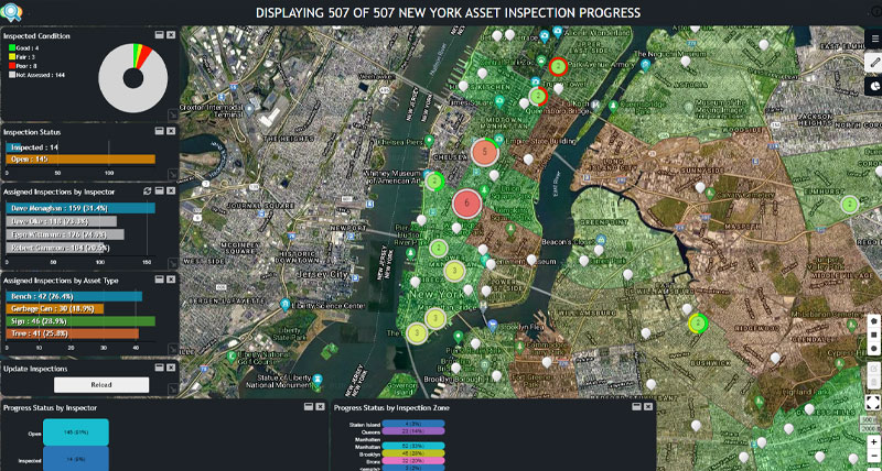
Public works
With Google Maps Platform, you have the location-based tools to support asset, field services, and fleet management for better public works, infrastructure, and facilities planning and operations. With it, you can:
- Enhance asset and work management systems with premium location-based content and capabilities
- Understand where assets are located, where they’ve traveled, and how often they’ve moved
- Create efficient routes for even the most complex fleet itineraries
- Track and visualize connected assets with precise location data
- Obtain the information needed to optimize performance, routes, fuel usage, and maintenance
APIs that support asset, field services, and fleet management include:
- Maps APIs display static and dynamic maps, including Street View images
- Geocoding API converts addresses to geographic coordinates, or the reverse
- Places API sends drivers to precise addresses based on reported locations
- Directions API provides directions and calculates current and future travel times based on real-time traffic
- Distance Matrix API delivers travel times and distances for one or more locations
- Roads API creates precise itineraries and returns posted speed limits for given road segments
More information

Map-Based view for law enforcement monitoring