lan
Hexagon Logo.svg
  • Contact us
  • Language Alert 한국어
    • Čeština
    • Deutsch
    • English
    • Español
    • Français
    • Italiano
    • Nederlands
    • Polski
    • Português
    • Türkçe
    • Русский язык
    • 日本語
    • 한국어


  • Products
  • Find a product
  • Find a partner
  • Contact sales

Explore our top technologies driving innovation across industries

    • Anti-jam systems

      A battle-proven A-PNT solution that prevents interference and jamming

    • ATS800

      Discover enhanced scanning accuracy and productivity with state-of-the-art laser trackers

    • Correction services

      Achieve centimetre-level accuracy for agriculture applications

    • Geospatial solutions

      Visualise and analyse geospatial data efficiently

    • Hexagon MinePlan OP Engineering Short Term

      All the tools an engineer needs to produce short-term tactical schedules for open pit mines

    • Hexagon OP Collision Avoidance System

      Protect people, vehicles, and equipment with 360-degree awareness and ongoing safety upgrades

    • Machine control and automation

      Solutions to increase accuracy, productivity, and uptime on-site

    • MAESTRO

      An all-digital CMM with transformative metrology technologies

    • Reality capture

      Capture accurate and detailed 3D digital realities of the physical world with multiple technologies

    • What we do
    • Technology overview

      Hexagon operates in metrology, reality capture, and positioning technology domains

    • Featured technologies
    • AI-driven solutions

      Find AI-enabled technologies to improve your business

    • Digital twins for industry

      Transform your business using digital twin technology

    • Robotics and autonomy

      Automate your systems with Hexagon’s pioneering robotics expertise

    • Explore research and development
    • Explore the Innovation Hub
    • Autonomy and perception

      Sensor, perception, steering, and software solutions to help you advance your autonomous platforms

    • Enterprise software for farms

      Software solutions for large companies to plan, optimise, analyse, and manage field operations

    • GNSS positioning

      Scalable positioning solutions, that simplify integration and expedite your time to market

    • Machine control

      Navigation and implement control solutions for precision agriculture

    • Explore all agriculture products
    • Airborne mapping

      Digitalise cities and countries with highly efficient airborne sensors and workflows

    • Geospatial content

      On demand high-resolution aerial imagery and elevation data

    • Laser scanning

      Capture, prepare, manage, and deliver point cloud data seamlessly

    • Mobile mapping

      Sensors and software to enable fast and comprehensive data collection on the go

    • Automated measurement systems

      Enabling the future of automated inspection

    • CAD/CAM & production software

      Enables manufacturers to generate, manage and optimise CNC machining toolpaths for efficient production

    • CAE software

      Enables designers and engineers to simulate product and process performance

    • Coordinate measuring machines (CMMs)

      From entry-level to ultra-high accuracy, CMMs for every requirement

    • Laser scanning

      Enable the non-contact digital capture of shapes and surface data for quality control and reverse engineering

    • Metrology software

      Customisable software that delivers intelligent and powerful data acquisition, analysis and reporting

    • Portable measuring systems

      Enable accurate measurement directly in the manufacturing environment to drive process improvement

    • Quality assurance software

      Allow operators, metrology technicians and engineers to act actively for quality improvements

    • Service and support

      Local service and support to help you overcome your manufacturing challenges and achieve your goals

    • Explore all manufacturing products
    • Evaluation, planning and design

      Leverage data to minimise loss, maximise precision, and realise true pit value

    • Drill and blast

      Strategically improve fleet management and equipment health

    • Load and haul

      Make sense and take action from monitor and survey data

    • Mine surveying and monitoring

      Unlock full resource value with data-driven mine planning and design

    • Processing

      Enhance process activity safety and efficiency form pit to port

    • Reclamation

      Plan operations with long-term sustainability in mind

    • Operational safety

      Gain insights to strengthen safety culture and prevent accidents

    • Autonomous operations

      Pave the way toward value-driven autonomous mining operations

    • Multi-sensor technology insights

      Data-driven insights to improve prediction, prevention and decisions

    • Explore all mining products
    • Anti-jam systems

      An assured positioning, navigation, and timing solution that protects against interference and jamming

    • Correction services

      Centimetre-level accuracy for land, airborne, or marine applications

    • GNSS antennas

      Maximise your GNSS receiver's positioning performance

    • GNSS receivers

      Deliver precise and reliable positioning, navigation, and timing solutions for a wide range of applications

    • GNSS/INS post-processing

      An ideal solution that refines GNSS and INS data to deliver highly accurate post-mission trajectories and mapping

    • GNSS/INS receivers

      Deliver reliable, continuous 3D position, velocity, and attitude performance

    • Resilience and integrity technology

      Enhance positioning, navigation, and timing (PNT) by providing detailed situational awareness and interference mitigation

    • SMART antennas

      High precision products that integrate a GNSS receiver and antenna into one compact enclosure

    • Visualisation software

      Provides critical information to make decisions regarding your quality of position

    • Explore all positioning products
    • AEC software

      Measure and verify construction projects with software that transfers design data into reality

    • Documentation and verification solutions

      Visualise, document, and verify every stage of construction projects

    • Laser scanning

      Capture, prepare, manage, and deliver point cloud data seamlessly

    • Total stations

      Measure accurately with high-performing manual, robotic, and scanning total stations

    • GNSS systems

      GNSS technology to enable positioning tasks with precision and accuracy

    • Survey software

      Seamless field and office workflows for surveying

    • Detection systems

      Detect, position, and document underground utilities for safer construction work

    • Digital realities platform

      Cloud-based storage, visualisation, and collaboration platform for geospatial data

    • Monitoring solutions

      Environmental and structural monitoring technology that deliver real-time movement insights

    • Mobile mapping

      Sensors and software to enable fast and comprehensive data collection on the go

    • Machine control

      Solutions for increasing productivity, efficiency, and safety in heavy construction machine operation

    • Geospatial content

      On-demand high-resolution aerial imagery and elevation data

    • Airborne solutions

      Sensors and processing workflows for airborne mapping

    • Levels

      Automatic, digital, and rotating laser levels for construction, surveying, monitoring and more

    • Explore all surveying and construction products
Featured platform

Nexus

A digital industrial platform for manufacturers to connect and collaborate across people, technology and data

nexus.png
Featured product

Leica TS20 Robotic Total Station

The robotic total station productivity powerhouse for everyday surveying, from cadastral to construction.

Leica TS20.jpg
  • Find a product
  • Contact sales

Explore solutions to transform your industry

    • Aerospace

      Enhance efficiency with advanced aviation technologies

    • Agriculture

      Enhance autonomy and productivity with advanced navigation and control solutions

    • Automotive

      Drive efficiency with integrated manufacturing and autonomy

    • Defence

      Boost security with integrated defence solutions

    • Energy and power utilities

      Optimise energy systems with intelligent monitoring and predictive analytics

    • General manufacturing

      Enhance productivity with smart manufacturing

    • Mining

      Boost efficiency with the power of one integrated solution

    • Public safety

      Data, insights and capabilities for better incident management and situational awareness

    • Aerospace
    • Agriculture
    • Automotive
    • Buildings
    • Construction
    • Consumer products
    • Defence
    • Education and research
    • Electronics
    • Energy and power generation
    • Engineering services
    • Government
    • Healthcare and life sciences
    • Mapping and geospatial content
    • Marine positioning
    • Mining
    • Public safety
    • Surveying
    • Transportation
    • Utilities and communications
    • Insights
    • Custom-build your AI

      Sector-specific data needs tailored solutions, not one-size-fits all

    • Level up your digital twins

      Unlock endless business value with the right reality capture tools

    • Create a robotics-first future

      Reimagine operations with an unparalleled automation portfolio

    • Thought leadership
    • Blogs
    • Newsletters
    • Magazines
    • Featured stories
    • AI-powered medical segmentation

      VGTRAINER and VGSTUDIO MAX help AnatomikModeling cut CT segmentation to 20 seconds per scan

    • Interpret 3D datasets with Coenradie

      Coenradie is elevating reality capture and AI-powered categorisation with Hexagon's point cloud software

    • Unlocking the universe with CERN

      How Hexagon enables hairpin precision at the world's leading physics lab

    • See all customer stories
    • Special reports
    • Future of robotics 2035 report

      Expert perspectives on robotics, automation, and autonomy for the next industrial era

    • Digital twin industry report

      Insights from 650+ executives on benefits, challenges, and the real impact

    • Advanced manufacturing report

      Strategy-defining insights on data, collaboration, and automation for manufacturing leadership

    • Your central hub for informational articles, in-depth research, reports and more
    • Magazines
    • Reports
    • Blogs
    • Events
Featured customer story

Shaping connection with Skanska

Skanska is building Norway’s Project Rogfast – the world’s longest and deepest road tunnel – with Hexagon’s technologies.

Hexagon Skanska featured card
  • Newsroom
  • Investor relations
  • Legal & Compliance
  • Sustainability
  • Contact us
    • About Hexagon

      The global leader in measurement technologies, helping the world's most vital industries build, navigate, and innovate

    • Our leadership
    • Our culture
    • Research and development
    • Ethics and compliance
    • Global locations
    • Careers

      Search opportunities that define the future

    • Sustainability at Hexagon

      Discover our sustainability goals and impact

    • Corporate social responsibility

      Learn how our CSR supports education, diversity, environment, and innovation

    • Supply and demand

      See how we embed sustainability from source to solution

    • Technology to power net-zero

      Explore how we are decreasing our carbon footprint

    • Annual and Sustainability report 2025
    • Our partners

      Meet the global innovators partnering with Hexagon

    • Find a partner

      Explore the partner directory

    • Become a partner

      Work with us to change the future

Octave Announcement

Octave completes separation from Hexagon

Learn more about Octave, now an independent public company following its separation from Hexagon in May 2026, encompassing Asset Lifecycle Intelligence, Safety, Geospatial and Infrastructure, ETQ and Bricsys.

R-evolution

R-evolution is the green tech business venture of Hexagon AB, positioned to put data to action to save our planet trough profitable impact projects around the globe.

BLK scanning Costa Rica

Contact us
Language Alert 한국어
  • Čeština
  • Deutsch
  • English
  • Español
  • Français
  • Italiano
  • Nederlands
  • Polski
  • Português
  • Türkçe
  • Русский язык
  • 日本語
  • 한국어

  • Products
  • Find a product
  • Find a partner
  • Contact sales
  • Find a product
  • Contact sales
  • Newsroom
  • Investor relations
  • Legal & Compliance
  • Sustainability
  • Contact us

Explore our top technologies driving innovation across industries

    • Anti-jam systems

      A battle-proven A-PNT solution that prevents interference and jamming

    • ATS800

      Discover enhanced scanning accuracy and productivity with state-of-the-art laser trackers

    • Correction services

      Achieve centimetre-level accuracy for agriculture applications

    • Geospatial solutions

      Visualise and analyse geospatial data efficiently

    • Hexagon MinePlan OP Engineering Short Term

      All the tools an engineer needs to produce short-term tactical schedules for open pit mines

    • Hexagon OP Collision Avoidance System

      Protect people, vehicles, and equipment with 360-degree awareness and ongoing safety upgrades

    • Machine control and automation

      Solutions to increase accuracy, productivity, and uptime on-site

    • MAESTRO

      An all-digital CMM with transformative metrology technologies

    • Reality capture

      Capture accurate and detailed 3D digital realities of the physical world with multiple technologies

    • What we do
    • Technology overview

      Hexagon operates in metrology, reality capture, and positioning technology domains

    • Featured technologies
    • AI-driven solutions

      Find AI-enabled technologies to improve your business

    • Digital twins for industry

      Transform your business using digital twin technology

    • Robotics and autonomy

      Automate your systems with Hexagon’s pioneering robotics expertise

    • Explore research and development
    • Explore the Innovation Hub
    • Autonomy and perception

      Sensor, perception, steering, and software solutions to help you advance your autonomous platforms

    • Enterprise software for farms

      Software solutions for large companies to plan, optimise, analyse, and manage field operations

    • GNSS positioning

      Scalable positioning solutions, that simplify integration and expedite your time to market

    • Machine control

      Navigation and implement control solutions for precision agriculture

    • Explore all agriculture products
    • Airborne mapping

      Digitalise cities and countries with highly efficient airborne sensors and workflows

    • Geospatial content

      On demand high-resolution aerial imagery and elevation data

    • Laser scanning

      Capture, prepare, manage, and deliver point cloud data seamlessly

    • Mobile mapping

      Sensors and software to enable fast and comprehensive data collection on the go

    • Automated measurement systems

      Enabling the future of automated inspection

    • CAD/CAM & production software

      Enables manufacturers to generate, manage and optimise CNC machining toolpaths for efficient production

    • CAE software

      Enables designers and engineers to simulate product and process performance

    • Coordinate measuring machines (CMMs)

      From entry-level to ultra-high accuracy, CMMs for every requirement

    • Laser scanning

      Enable the non-contact digital capture of shapes and surface data for quality control and reverse engineering

    • Metrology software

      Customisable software that delivers intelligent and powerful data acquisition, analysis and reporting

    • Portable measuring systems

      Enable accurate measurement directly in the manufacturing environment to drive process improvement

    • Quality assurance software

      Allow operators, metrology technicians and engineers to act actively for quality improvements

    • Service and support

      Local service and support to help you overcome your manufacturing challenges and achieve your goals

    • Explore all manufacturing products
Featured platform

Nexus

A digital industrial platform for manufacturers to connect and collaborate across people, technology and data

nexus.png
    • Evaluation, planning and design

      Leverage data to minimise loss, maximise precision, and realise true pit value

    • Drill and blast

      Strategically improve fleet management and equipment health

    • Load and haul

      Make sense and take action from monitor and survey data

    • Mine surveying and monitoring

      Unlock full resource value with data-driven mine planning and design

    • Processing

      Enhance process activity safety and efficiency form pit to port

    • Reclamation

      Plan operations with long-term sustainability in mind

    • Operational safety

      Gain insights to strengthen safety culture and prevent accidents

    • Autonomous operations

      Pave the way toward value-driven autonomous mining operations

    • Multi-sensor technology insights

      Data-driven insights to improve prediction, prevention and decisions

    • Explore all mining products
    • Anti-jam systems

      An assured positioning, navigation, and timing solution that protects against interference and jamming

    • Correction services

      Centimetre-level accuracy for land, airborne, or marine applications

    • GNSS antennas

      Maximise your GNSS receiver's positioning performance

    • GNSS receivers

      Deliver precise and reliable positioning, navigation, and timing solutions for a wide range of applications

    • GNSS/INS post-processing

      An ideal solution that refines GNSS and INS data to deliver highly accurate post-mission trajectories and mapping

    • GNSS/INS receivers

      Deliver reliable, continuous 3D position, velocity, and attitude performance

    • Resilience and integrity technology

      Enhance positioning, navigation, and timing (PNT) by providing detailed situational awareness and interference mitigation

    • SMART antennas

      High precision products that integrate a GNSS receiver and antenna into one compact enclosure

    • Visualisation software

      Provides critical information to make decisions regarding your quality of position

    • Explore all positioning products
    • AEC software

      Measure and verify construction projects with software that transfers design data into reality

    • Documentation and verification solutions

      Visualise, document, and verify every stage of construction projects

    • Laser scanning

      Capture, prepare, manage, and deliver point cloud data seamlessly

    • Total stations

      Measure accurately with high-performing manual, robotic, and scanning total stations

    • GNSS systems

      GNSS technology to enable positioning tasks with precision and accuracy

    • Survey software

      Seamless field and office workflows for surveying

    • Detection systems

      Detect, position, and document underground utilities for safer construction work

    • Digital realities platform

      Cloud-based storage, visualisation, and collaboration platform for geospatial data

    • Monitoring solutions

      Environmental and structural monitoring technology that deliver real-time movement insights

    • Mobile mapping

      Sensors and software to enable fast and comprehensive data collection on the go

    • Machine control

      Solutions for increasing productivity, efficiency, and safety in heavy construction machine operation

    • Geospatial content

      On-demand high-resolution aerial imagery and elevation data

    • Airborne solutions

      Sensors and processing workflows for airborne mapping

    • Levels

      Automatic, digital, and rotating laser levels for construction, surveying, monitoring and more

    • Explore all surveying and construction products
Featured product

Leica TS20 Robotic Total Station

The robotic total station productivity powerhouse for everyday surveying, from cadastral to construction.

Leica TS20.jpg

Explore solutions to transform your industry

    • Aerospace

      Enhance efficiency with advanced aviation technologies

    • Agriculture

      Enhance autonomy and productivity with advanced navigation and control solutions

    • Automotive

      Drive efficiency with integrated manufacturing and autonomy

    • Defence

      Boost security with integrated defence solutions

    • Energy and power utilities

      Optimise energy systems with intelligent monitoring and predictive analytics

    • General manufacturing

      Enhance productivity with smart manufacturing

    • Mining

      Boost efficiency with the power of one integrated solution

    • Public safety

      Data, insights and capabilities for better incident management and situational awareness

    • Aerospace
    • Agriculture
    • Automotive
    • Buildings
    • Construction
    • Consumer products
    • Defence
    • Education and research
    • Electronics
    • Energy and power generation
    • Engineering services
    • Government
    • Healthcare and life sciences
    • Mapping and geospatial content
    • Marine positioning
    • Mining
    • Public safety
    • Surveying
    • Transportation
    • Utilities and communications
    • Insights
    • Custom-build your AI

      Sector-specific data needs tailored solutions, not one-size-fits all

    • Level up your digital twins

      Unlock endless business value with the right reality capture tools

    • Create a robotics-first future

      Reimagine operations with an unparalleled automation portfolio

    • Thought leadership
    • Blogs
    • Newsletters
    • Magazines
    • Featured stories
    • AI-powered medical segmentation

      VGTRAINER and VGSTUDIO MAX help AnatomikModeling cut CT segmentation to 20 seconds per scan

    • Interpret 3D datasets with Coenradie

      Coenradie is elevating reality capture and AI-powered categorisation with Hexagon's point cloud software

    • Unlocking the universe with CERN

      How Hexagon enables hairpin precision at the world's leading physics lab

    • See all customer stories
Featured customer story

Shaping connection with Skanska

Skanska is building Norway’s Project Rogfast – the world’s longest and deepest road tunnel – with Hexagon’s technologies.

Hexagon Skanska featured card
    • Special reports
    • Future of robotics 2035 report

      Expert perspectives on robotics, automation, and autonomy for the next industrial era

    • Digital twin industry report

      Insights from 650+ executives on benefits, challenges, and the real impact

    • Advanced manufacturing report

      Strategy-defining insights on data, collaboration, and automation for manufacturing leadership

    • Your central hub for informational articles, in-depth research, reports and more
    • Magazines
    • Reports
    • Blogs
    • Events
    • About Hexagon

      The global leader in measurement technologies, helping the world's most vital industries build, navigate, and innovate

    • Our leadership
    • Our culture
    • Research and development
    • Ethics and compliance
    • Global locations
Octave Announcement

Octave completes separation from Hexagon

Learn more about Octave, now an independent public company following its separation from Hexagon in May 2026, encompassing Asset Lifecycle Intelligence, Safety, Geospatial and Infrastructure, ETQ and Bricsys.

    • Careers

      Search opportunities that define the future

    • Sustainability at Hexagon

      Discover our sustainability goals and impact

    • Corporate social responsibility

      Learn how our CSR supports education, diversity, environment, and innovation

    • Supply and demand

      See how we embed sustainability from source to solution

    • Technology to power net-zero

      Explore how we are decreasing our carbon footprint

    • Annual and Sustainability report 2025

R-evolution

R-evolution is the green tech business venture of Hexagon AB, positioned to put data to action to save our planet trough profitable impact projects around the globe.

BLK scanning Costa Rica
    • Our partners

      Meet the global innovators partnering with Hexagon

    • Find a partner

      Explore the partner directory

    • Become a partner

      Work with us to change the future


Searching...
No results found
  1. Home
    >
  2. Products
    >
  3. Explore product groups
    >
  4. 측정 하드웨어
    >
  5. 3D 레이저 스캐너
    >
  6. 레이저 스캐너용 소프트웨어
    >

레이저 스캐너용 소프트웨어

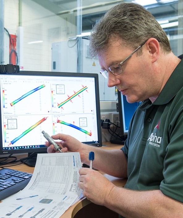
소프트웨어는 레이저 스캐너 사용 시 중요한 역할을 합니다. 강력한 프로그램이 휴대용 측정 암, 레이저 트래커 시스템 또는 고정식 3차원 측정기와 함께 스캐너 사용을 지원합니다.

측정 및 검사 소프트웨어

이상적인 측정 소프트웨어를 찾아보십시오

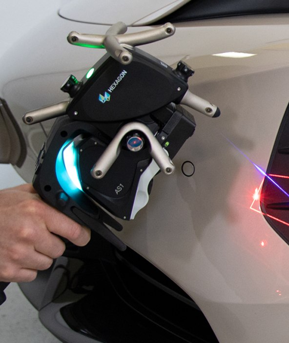
레이저 스캐너와 함께 사용하도록 최적화된 측정 소프트웨어 솔루션을 확인해 보십시오.

레이저 스캐너용 소프트웨어

VISI Reverse

VISI Reverse는 하이브리드 모델링 CAD 기능과 3D 스캔 데이터 처리 기능을 겸비하여, 고객이 스캔한 데이터를 기점으로 완벽하게 호환 및 편집 가능한 솔리드 모델을 생성할 수 있습니다.

자세히 보기

이동식 측정용 소프트웨어

소프트웨어 다운로드

당사의 전용 소프트웨어 포털을 방문하여 지원 문서를 열람하고 최신 소프트웨어를 다운로드하십시오.

소프트웨어 포털

HxGN LIVE Global hero letters with coloured strobe lighting for dramatic effect

HxGN LIVE

Hexagon의 연간 국제 컨퍼런스 HxGN LIVE에서는 감동적인 기조 연설, 열린 네트워크, 눈 여겨 보아야하는 첨단 기술들을 제공됩니다.

더 자세히 알아보기

산업용 3D 레이저 스캐너

산업용 3D 레이저 스캐너

레이저 스캐너는 품질 보증에서 중요한 역할을 합니다. 레이저를 사용하여 형태 및 표면의 3D 디지털 캡처를 수월하면서도 정밀하게 할 수 있습니다.

자세히 보기

Get started

  • Contact sales
  • Search all products
  • Global locations
  • Get support
  • Start your career

Discover Hexagon

  • Who we are
  • Leadership
  • Sustainability
  • Investor relations

Explore more

  • Customer stories
  • Upcoming events
  • Newsroom
  • Ethics and compliance
  • Legal
  • Privacy
  • Terms of use
  • Imprint
  • Report website issue
  • Cookie settings
© Hexagon AB and/or its subsidiaries. All rights reserved.
Language Alert 한국어
  • Čeština
  • Deutsch
  • English
  • Español
  • Français
  • Italiano
  • Nederlands
  • Polski
  • Português
  • Türkçe
  • Русский язык
  • 日本語
  • 한국어