The 3D digitisation of the Hadrian's Temple
Austrian Archaeological Institute - Austria
Contact us
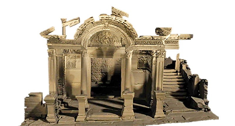
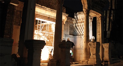
The Hadrian’s Temple, discovered in 1956 in Ephesus, Turkey, is undeniably one of the most significant historical monuments in the region. As far back as the summer of 1957, comprehensive restoration work had begun and was completed in 1958. Questions about the building’s chronology, function or reconstruction details, however, could never be conclusively answered. A special project, initiated by the Austrian Archaeological Institute (ÖAI) and funded by the Austrian Science Fund, has set out to shed light on these unsolved aspects.
Objective and measuring object
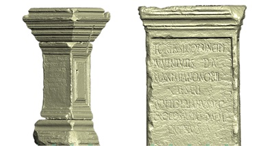
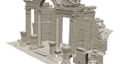
To study this historical building and its numerous details, first of all the architectural and historical parameters of the building structure have to be established. This is accomplished by generating a high-resolution three-dimensional surface replica of the Hadrian’s Temple, facilitating the production of an up-to-date archaeological profile of the building including a detailed documentation of each stone along with all its respective cuttings, tool marks and ornamentation. An essential objective is the generation of orthoimages which are used for the mapping of crevices and fissures by a specialist restorer to compare the original building components of the temple against its modern additions.
Creating drawings by hand not only is significantly more time consuming than using 3D scans, it also requires erecting scaffolding for an extended period of time. The three-dimensional data acquisition of the temple thus not only helps to save considerable time, it also eliminates the factor of a subjective documentation: Objective, precise 3D data allows for a detailed, fact based interpretation.
Measuring system and setup
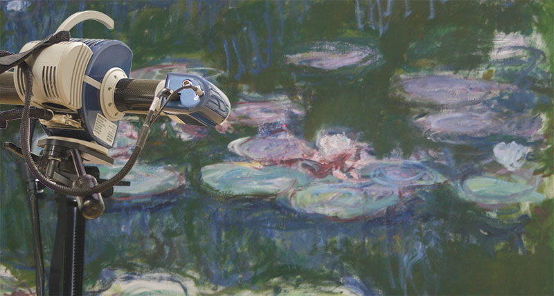
The documentation of marble blocks, in particular those with numerous embellishments as in the case of the Hadrian’s Temple, requires a very high level of feature accuracy. The AICON SmartScan enables the 3D digitisation of archaeological objects such as sculptures or buildings at the highest level of resolution and accuracy to detail. Furthermore, the texture and colour of the object are also captured, providing a one-to-one, pixel-true correspondence of 3D coordinates and colour information.
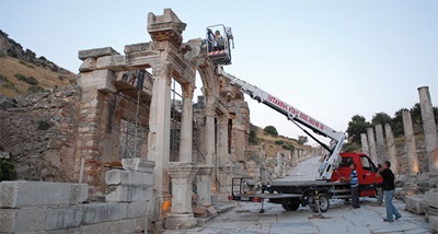
The Hadrian’s Temple measures an area of approx. 10 x 10 m in plan with an overall height of approx. 8 m, which is why the AICON SmartScan using measuring fields of 600 mm and 1,400 mm has been chosen for this scanning task. A 6 m high scaffolding as well as mounting the scanner onto an up to 3 m extendable tripod ensure the necessary operating proximity of the measuring system to the scan object. To ensure optimal ambient light conditions, all measurements are taken during night time.
Workflow
 To ensure prime accuracy of the scans down to the millimetre for the entire temple, the high-definition surface scans are created with the aid of photogrammetric measurement using around 75 reference markers (Carried out with the mobile coordinate measuring machine AICON MoveInspect DPA). 35 of these reference markers are additionally measured using a theodolite, a special precision instrument for measuring angles in the horizontal and vertical planes. Using the resulting data, the position of the temple and its surrounding environment can be transferred at a 1:1 scale into the Ephesus reference system.
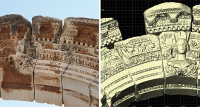
The original marble frieze blocks of the building are on display in the Efes museum in Selçuk, while cast replicas made of concrete are used for the reconstruction on site. Both the original reliefs in the museum as well as the replicas are scanned. The direct comparison through superimposition allows the impressive visualisation of the damage caused to the concrete casts on-site as a result of exposure to the elements and weathering over the past fifty years.
 In addition to the building components of the existing reconstruction, also a number of other architectural objects are scanned. The resulting 3D data now serves as a basis for the construction of their virtual replicas. Upon completion of capturing the objects, the individual data sets are merged into one joint polygon mesh. Where necessary, small holes can be filled automatically with the help of the AICON scanning and evaluation software OptoCat.
Conclusion
As the scan images illustrate, concealing the texture of the 3D model can be of a significant advantage: With the marble not showing any form of discoloration caused by soiling, for instance, the 3D structure is much more clearly identified.
In the course of the scanning project, each element of the building complex is scanned. Comparing these against the 3D replica of the temple itself, it is possible to verify whether the reconstructed parts correctly correspond with their architectural remainders, in particular with regard to their distinct joining and tool marks. Depending on the result of this verification, alternative reconstruction methods may have to be considered.
 An additional aspect of the data post-processing is the generation of orthoimages for publications or cartographic material.
In summary, the 3D data sets generated with the help of the AICON SmartScan not only provide an important means for the documentation of the Hadrian’s Temple. They furthermore deliver significant and crucial information to finally shed light on complex architectural questions and inconsistencies.
We would like to express our appreciation to Dr. Ursula Quatember and Barbara Thuswaldner of the Austrian Archaeological Institute in Vienna, Robert Kalasek of the Vienna University of Technology (Austria), J. Koder and S. Ladstätter of the Ephesus excavation team, C. Topal, Director of the Efes Müzesi Selçuk, F. Otztürk and Ch. Kurtze for their valuable support and contributions leading to the success of this project.