3D White light scanning at the historical huts of Scott and Shackleton
Geometria - Antarctica
Contact us
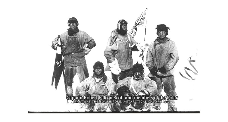
KO21 is a long-term multidisciplinary study investigating, amongst other aspects, the effects of biological and non-biological deterioration on the Heroic Era huts of the two famous British polar explorers Robert Falcon Scott and Ernest Shackleton on Ross Island.
New Zealand based Geometria, an advisory and research services provider in the fields of archaeology and cultural heritage management, joined this project in 2010 and has since conducted several surveys using three-dimensional scanning equipment, such as a AICON Scanner, for high-definition recordings of the huts and their surroundings. The long-term results will help various scientists to interpret and model their data as well as to visualize and remotely interpret these isolated sites for educational purposes and ongoing heritage conservation management.
Objective and measuring object
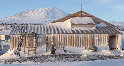
During January 2011, members of Geometria and the University of Waikato (New Zealand) made their way to Ross Island (Antarctica) to conduct a comprehensive 3D white light and laser scanning project of Scott´s huts at Hut Point and Cape Evans as well as Shackleton´s hut at Cape Royds. The resulting scan data will not only support multi-disciplinary studies but also help to develop interpretative models for broader public consumption.
Although these huts of the famous British Antarctic Expedition Terra Nova (1910 - 1913) have been exposed to the elements in one of the most inhospitable environments on earth for over a century, they are preserved in amazingly good condition. Because of their remoteness, the huts have not been subjected to major human impact since their abandonment about 100 years ago. The significance of these sites regarding their cultural heritage as well as their inaccessibility necessitates their digital recording, modelling and remote interpretation for detailed scientific studies.
Measuring system and setup
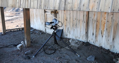
The AICON SmartScan was chosen for the challenge of a 3D scanning project of this magnitude in harsh Antarctic conditions to deliver consistent and dependable performance as well as generate highly precise scan data.
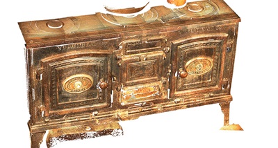
It consists of a projector unit located in the middle of the scanner base which, based on the operation principle of the miniaturized projection technique, rapidly projects a vast number of fringe light patterns onto the measuring object. Each end of the two sensor bases is equipped with a high-resolution 5 megapixels digital colour camera, capturing every single projection point of the patterns formed of the object surface. A special algorithm then performs a triangulation calculation to measure the exact position of each point within the fringe pattern, processing up to millions of points for each scan.
Workflow
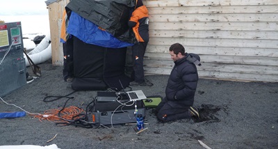
Due to the harsh environmental conditions and pressure from an increasing number of visitations, both the structures of the huts as well as their contents are in urgent need for detailed scientific study, archiving and modelling for interpretive purposes. Given a limited time frame of only 12 field days for this project, the comprehensive 3D data acquisition of a measuring project of this size and volume is a challenging task. Nevertheless, the expedition members managed to digitise a lot of the huts’ exterior structures as well as various artefacts found inside the abandoned huts.
Thanks to the high-resolution colour cameras of the AICON SmartScan, all objects have been captured not only at very high level of accuracy and adherence to detail but also in their actual colours.
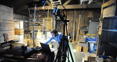 Due to the interfering influence of ambient light, scanning outside the huts posed the biggest challenge: In the Antarctic summer with 24 hours of daylight, the light comes in from all angles and, to add to the challenge, is reflected by the snow. Any scanning work on the external surfaces of the huts had therefore to be carried out under cover of large makeshift light protection shields.
For future scanning projects in Antarctica, the team plans to work with collapsible light shields. The scanner was used in freezing temperatures varying from -2°C to -12°C which did not have any impact on the system itself or the quality of the generated scan data, therefore making the stable working AICON SmartScan is an excellent system for demanding and challenging field work!
Conclusion
The AICON Scanner allows for truly accurate and authentic recordings of the current conditions of the hut structures as well as of their interiors. The digital data produced in this project constitutes an essential part in the planning and implementation of the ongoing conservation of these remarkable sites. It also serves as basis for scientific and educational interpretation of the polar researchers’ huts and their dissemination allows a broad spectrum of users to work on individual specific analyses or interpretations. Archaeologists, conservators, conservation architects, or microbiologists are all equally interested in the interpretation of different aspects of the cultural heritage as well as the history of these sites.
The AICON SmartScan has proven to be the perfect system for 3D digitisation in this demanding environment. With suitable protection from ambient light, this scanner consistently delivers top-quality data at remarkable resolution and adherence to detail — even at fluctuating or very low temperatures.
“Using the AICON SmartScan we were able to fulfil our project aims for the 2011 field season. We confirm the capacity of this equipment to capture the data at the highest resolutions that our project partners require. More importantly, the operability and reliability of the AICON SmartScan has been proven in the harsh Antarctic environment where equipment failure is common.” (Russell Gibb, Geometria Ltd.)
We would like to thank the staff of Geometria Ltd. New Zealand for their kind contribution of the information and photographs to compile this report. Upon request, we are pleased to provide a bibliography of related articles.
Literature
- Antarctic Heritage Trust, Conservation Report: Shackleton’s Hut. British Antarctic Expedition 1907-1909, Christchurch, 2003
- Antarctic Heritage Trust, Conservation Plan:
Discovery Hut, Hut Point, Christchurch, 2004
Scott’s Hut, Cape Evans, Christchurch, 2004