Learn more about GeoSlate
Easy to use mobile geological-logging application simplifies field data collection.
The current page is available in the following languages:
Select your preferred language from the list below. We will show you content in your preferred language when available, otherwise we will show English.
Preferred Language
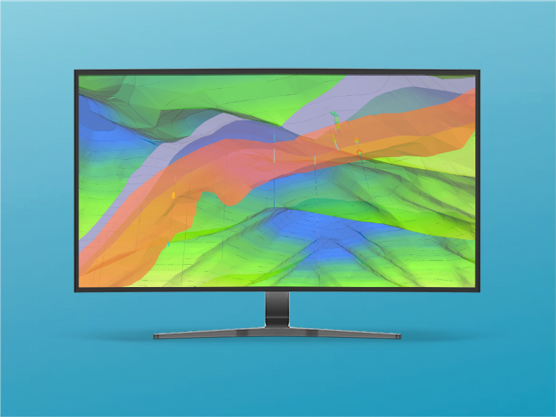
Connect smart field data from on-site tablet devices to MinePlan 3D and take exploration projects from the initial drillhole design and planning stages through field data collection, data management, QAQC, 3D interpretation, and geomodeling.
Collect field drillhole data on mobile tablet devices using the GeoSlate mobile app then sync directly and instantly to MinePlan 3D.

.png?h=334&iar=0&w=800&hash=2C0C7699DE213D14207F2052891E7148)


HxGN MinePlan Exploration Geo is a complete software package for exploration geology that brings smart field data collection on tablet devices together with the MinePlan 3D desktop solution. It provides everything needed by geoscientists to take exploration projects from the initial drillhole design and planning stages through field data collection, data management, QAQC, 3D interpretation, and geomodeling.
Field drillhole data can be collected on mobile tablet devices using the GeoSlate mobile app and synced directly and instantly into MinePlan 3D. Use this data to interpret, interpolate and report on reliable and auditable geological models that can be quickly and easily updated with new information, saving time and money.
Drillhole design tool simplifies the field program design process with interactive functions for drillhole targeting and simulating deviation.
The GeoSlate logging app offers an intuitive, workflow-centric field logging interface optimized for rugged Android tablet devices.
Real-time data validation controls quality and consistency between field personnel and saves time.
Easy to use mobile geological-logging application simplifies field data collection.
Productive mines and exploration projects depend on being able to build detailed geologic and resource models based on timely and efficient collection of geological data.
View your downhole core images directly in MinePlan Drillhole Manager.
Torque is an SQL-based database platform for managing drillhole, blasthole, and other sample data with advanced functionality for data processing and QAQC validation.
.jpg?h=330&iar=0&w=592&hash=444C342799265C53C0A8AA77E8F07EE1)