A400M automated assembly with Leica Geosystems laser trackers
Airbus Military - Spain
Contact us
The Final Assembly Line at the Airbus Military facility in Seville, Spain, is the third largest aeronautical station in Europe after Toulouse and Hamburg and welcomes the final assembly and delivery of the A400M, the latest Airbus Military airplane. Designed to a recognised requirement for a new airlifter for European air forces, the A400M incorporates state-of-the-art materials and technology that are being continuously perfected in today’s civil aircraft fleets.
Designed to a recognised requirement for a new airlifter for European air forces, the A400M incorporates state-of-the-art materials and technology that are being continuously perfected in today’s civil aircraft fleets.
The A400M or “grey giant” project is the biggest carbon fibre wings assembly project in the Airbus Group and is a major step for the future assembly project of the A350. Features such as electronic flight controls, carbon composite structures and an automated handling system will bring new standards of operability and safety to military aircrews. The 600 M Euros investment for the factory should see an annual production of 28 aircraft once the high output is achieved.
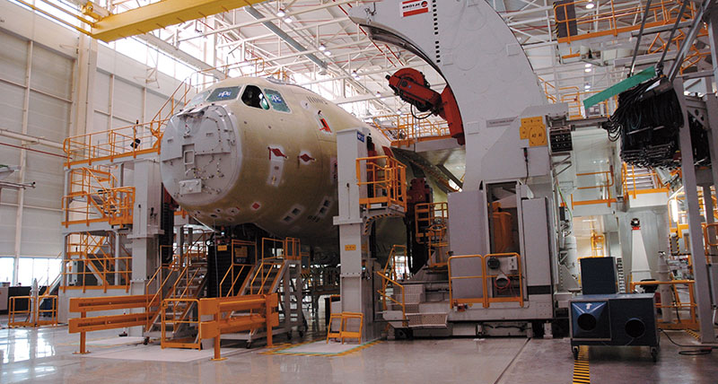
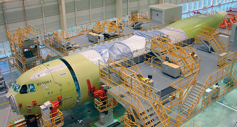
 The assembly of the A400M military aircraft is divided in different stations. The first station is for the wings, putting together the central box produced in France and the outer wings provided from the Broughton, UK. The second station is in charge of the fuselage, composed from a German made centre-rear part and a French “nose”. The third and final station is for the complete assembly of the first two parts, along with the engine and tail plane, to complete the final aircraft. Whilst the three stations are in charge of assembling the different parts, they are also responsible for the installation of the fuel system, electrical system, hydraulic parts, air, etc… On completion of the assembly the A400M comes to a last testing station where more then 600 functional tests are carried out. The final control will result in a special station where 50 to 100 points will be measured before and after test flights.
The tender’s objectives of EADS A400M assembly project was simple: to find a flexible, automated, simple and quick solution to measure the whole spatial geometry of the airplane! The benchmark only concerned two laser tracker suppliers. Salomon Benasuly, responsible of the measuring system for the fuselage assembly station remembers: “We did a lot of dual testing between the two brands, expecting to choose the best of them. Even if the first tracker was always within specification, the Leica Geosystems laser tracker reached much better accuracy – well within the ones they specify - and a better repeatability. Having also already a long and positive experience with the laser tracker and the services provided from Hexagon Metrology, the results confirmed our choice.”
In fact, EADS already employs the combination of laser trackers with a NC positioner for the Falcon F7X at Airbus Military for the HTP (Horizontal Tail Plane) assembly. Next to this, Airbus Military has used Leica Geosystems laser trackers for tooling assembly & controlling different airplane parts and engineering. Almost all of the jigs are measured with Leica LTD. The Leica Geosystems trackers became an important part of the EADS’ quality process.
 EADS then started to use a big NC positioner for the fuselage, the wings & the assembly of the fuselage with the wings, working always with two Leica Geosystems laser trackers in order to have the best visibility. But the challenge of the automation and integration project was threefold because of the three different kinds of NC software used for each of the assembly stations. The emScon open architecture made the integrations very easy for the subcontractors. On the fuselage assembly station, eight cameras are in charge of controlling the rivet positions as well as controlling the general security of the station. There is no operator controlling the two Leica Geosystems laser trackers. Salomon Benasuly explains: “the software is controlling everything.
A trained operator makes a field check and a reflector check once in a while before the measurement process. That’s all!” He goes on: “The trackers are feeding back to the control of the NC positioner, reading it with the laser tracker. The data goes back into the controller of the NC positioner and the controller calculates where it is and where it has to go. Once the correct position is achieved, the position is stored and used for the entire process. No more corrections are needed after this.” The Leica Geosystems laser trackers’ open architecture and fully automated system allow measurement time in two minutes. “Such a measurement would be impossible to realise manually, unless having a few spare hours”, adds Emma Barrio, Hexagon Metrology portable product sales engineer.
Even if the complete measurement activity represents an important work, it is often not considered as part of the production process. To be quick and precise helps in decreasing the global assembly time of the A400M.
The last and final check will also need an automated process with a laser tracker or a laser station with manufactured dedicated tools to make the measurement as easy as possible.